
Vicharn Group (VG) to invite investors in Thailand or abroad to buy land allocated for doing business related to water-related residences on artificial islands

Blue Heaven 2-0 (BH2-0)
A paradise island on a 5-meter-high hill, 30 rai
Within the 50-rai plot of land, there are currently no houses on the hill.
By Khun Owl AI & VG
"Disclaimer" : Images and details are part of the project MIT and Model BH development process and may be subject to change as needed depending on site conditions. We reserve the right to notify you of any changes in advance.

1.) "The BH 2-0 model is not just about land allocation; it's about creating 'security' in a volatile world. This is the only place where you can own both fortress-level security and paradise-like beauty."
2.) The BH 2-0 model features: 1. A bare earthen mound with no houses or buildings on it. 2. A circular mound of 30 rai (approximately 12 acres), 5 meters high at a 3-meter elevation, totaling 8 meters from the top. 3. Tied slopes and pathways for planting flower gardens. 4. A 100-meter wide white sandy beach surrounding the base of the mound. 5. A 3-rai (approximately 1.2 acres) circular pond on the mound, with additional ponds surrounding the beach. A tree-lined dirt road extends to the 3-meter concrete fence. 6. A square concrete fence. 6.) The outer fence is 4 meters high to prevent flooding, and the inner fence is 1 meter above the dirt road. 7.) The area between the pond and the beach is circular, and the area between the pond and the dirt road is a square. 8.) There is an entrance/exit gate at a normal level of 3 meters, with a sloping road leading down to the front road.
3.) The BH 2-0 model will be the prototype for all MIT projects, or for projects outside of MIT where there is a desire to create a 30-rai (approximately 16-acre) mound 5 meters high that will include water, a beach, a dirt road, and a 4-meter high fence that can permanently prevent flooding.
4.) Key Selling Points of the BH 2-0 Model: The Fortress of Paradise
"The safest paradise on a hill for future living and investment."
1. Extreme Safety & Flood Protection:
• 4-meter high concrete fortifications: Surrounding the entire area to prevent intrusion from outsiders and thieves, providing maximum privacy.
• 100% flood protection system: With a concrete water barrier fence and a raised earthen mound totaling 8 meters (3-meter base + 5-meter pancake mound), ensuring your property is safe from all forms of flooding.
• Geological Stability: The project is located in a location not in an earthquake zone, providing peace of mind for long-term building and structure construction.
2. The Sanctuary of Exclusive Privacy:
• Distinctive, but not isolated: With a unique pancake-shaped artificial island design, one of a kind in the world, you will stand out as the project owner. But it still remains conveniently connected to the outside world via a main entrance bridge with strict access control.
• Private White Sand Beach: A relaxation area sloping from a hill down to a clear water canal, allowing you to experience a world-class resort atmosphere in your own private space.
3. Aesthetic & Living Harmony
• Three-tiered flower garden on a slope: Be amazed by the view of a vibrant flower garden (red-yellow) planted in tiers along the three slopes, creating freshness and adding value to the area.
• Shade along the fence: The pedestrian walkway around the project is planted with trees providing shade, perfect for relaxing walks or exercising in a peaceful atmosphere.
• Clear water canal in the heart of the project: Over 10 rai of water area surrounding the hill. It helps to cool the temperature and create a relaxing atmosphere with the sound of water and the view of green spaces contrasting with the blue water surface.
4. Ultimate Investment Opportunity (Unlimited Business Opportunities)
• Flexible 50 Rai Area: Ideal for building luxury mansions, a Wellness Center, or an Organic Business Complex on top of a 30 Rai hill designed to catch the breeze and offer 360-degree views.
• Infrastructure Ready: We provide complete infrastructure (Infrastructure Turnkey), including earthworks, water systems, and flood protection, ready for you to immediately expand your business or residence.
5.) The BH 2-0 Model (The Pancake Island) focuses on extracting sand and mud to create a 5-meter-high earthen mound (total height from the normal level of 8 meters) to create a 30 Rai earthen mound on a total area of 50 Rai, to meet the needs of sustainability and permanent flood protection.
General characteristics of the BH-2-0 model:
1.) There is a pancake-shaped mound in the center, 5 meters high and 30 rai (approximately 12 acres) in size, in a circular shape. There are no houses or buildings on the mound. The base of the mound is 3 meters above the normal level, with a pedestrian road surrounding it.
2.) Around the base of the mound, there is a gentle slope with a road for vehicles and a walkway leading from the base to the top. At the top of the slope is the "Heart of the Hill," designed for planting flower gardens and ground cover plants in three terraced levels, with pedestrian roads between the levels.
3.) On the mound is an oval-shaped pond, 3 rai (approximately 1.2 acres). 4.) At the base of the mound and the road surrounding it, there is a circular white sandy beach at the same level as the pedestrian road, less than 3 meters above the normal level. The beach gradually slopes down to a small canal. The beach is approximately 100 meters wide from the pedestrian road around the base of the mound.
4.) There is a small canal. There will be remaining areas from points 1 to 4, and the highest water level will be approximately 2.5 meters above normal level. The side facing the white sand beach will be a circle, while the other side will be a square.
5.) There will be a small concrete breakwater to prevent water from the canal from eroding the embankment of the pedestrian street (which will be approximately 3 meters above normal level).
6.) There will be a bridge from the entrance/exit gate across the canal.
7.) There will be an entrance/exit gate.
8.) There will be a concrete water barrier fence in the shape of a square, convenient for measuring the land. The outer fence will be 4 meters high from the normal ground level to allow for a total area of 50 rai. The inner fence will be only 1 meter high, with a dirt road for pedestrians at a height of 3 meters above normal level, running along the concrete fence with trees planted at intervals.
2.) Calculation and construction planning of the BH 2-0 (The Pancake Island) model, which focuses on dredging sand and mud to create a 5-meter-high earthen mound (total height 8 meters above the normal level) to build a 30-rai (approximately 12-acre) earthen mound on a total area of 50 rai (approximately 8 hectares) to address sustainability and permanent flood protection. The details are as follows:
1. Earthwork Estimation
For model BH 2-0 with a 5-meter high mound and supported by a base 3 meters above normal level (total 8 meters):
Cut Volume: For a 30-rai area, if sand and mud are dredged to create a 5-meter high mound, approximately 240,000 - 300,000 cubic meters of soil will be needed (calculated from area x average height + 20-30% allowance for settlement).
Project Duration (2.7 years): This aligns with the operation of a medium-sized dredging vessel, which requires simultaneous work while waiting for soil settlement and mud drainage.
2. Engineering Structures and Key Components
The Base: A base 3 meters above normal level, consisting of a concrete fence and earthen roads surrounding the project, acting as a permanent "first line of defense" against flooding.
Pancake-shaped Mound (5 meters): The upper mound is 5 meters high above the lower earthen road, designed with a balanced slope. For the stability of future building construction:
3-rai hilltop pond: Excavate to a depth of 3-4 meters on the hilltop to serve as a private water bank. Lined with 100% HDPE Geo-Membrane and connected to a drainage canal system below.
3. Preliminary Bill of Quantities (BOQ): Model BH 2-0

4. Key Features and Selling Points (Presentation Points)
Permanent Flood Protection: With a total height of 8 meters above the normal level (3 m base + 5 m slope), the project is guaranteed 100% safe from future flooding.
Sustainable Ecosystem: Sand is dredged from our own land, reducing the need for imported materials (Zero Waste), and the use of waterproof membranes ensures clear and clean water in the drainage ditches year-round.
Foundation for Future: The well-compacted slope structure, processed for 2.7 years, will be sufficiently firm for the construction of stable houses or buildings.
5. Risk Management Measures (Risk Management)
Plastic Seams: Although only 5 meters high, static water pressure still has an effect. A sub-drain system must be installed to drain any water escaping under the plastic sheeting into monitoring wells.
Settlement: Due to the use of quicksand and mud, the 2.7-year period is a crucial time for natural soil settlement before building construction begins.
3.) Key Features of the BH 2-0 Model:
The main feature is the creation of an artificial mound or island with an upper layer 15 meters high. The base of the artificial mound is level with a 5-meter-high artificial white beach, covering a 22-rai (approximately 8.8 acres) area. This is surrounded by a system of canals and an artificial beach totaling 9 rai (approximately 3.2 acres). The beach is enclosed by a concrete breakwater 5 meters high above the lower dirt road. A 1-meter-high concrete fence with a raised edge, a gate for entry and exit, and a raised dirt road along the inner edge of the concrete fence are all 3 meters high above normal level. Therefore, the beach base or the foundation of the mound is a total of 8 meters above normal level, permanently situated on a raised platform to prevent flooding. This design addresses both the aesthetic appeal and the sustainability of an organic agricultural ecosystem.
The key strategies we employ to ensure the success and maximum safety of this project comprise four pillars:
1.) Innovative Water Management (Smart Water Grid): We utilize a closed contour swale system lined with HDPE liners to prevent 100% water seepage into the ground. This allows us to control water levels and create a "white beach" around the project year-round, even during the dry season.
2.) Safety Engineering (Safety & Stability): With a ground elevation of 15 meters, we designed a sub-drain system beneath the plastic to release water and gas pressure, preventing landslides. The installation adheres to international standards, with every weld inspected using a compressed air system.
3.) Five-Level Forest Ecosystem (Ecological Wealth): We didn't just plant trees; we designed a "symbiotic forest" with over 10 plant species planted in a staggered pattern to stabilize the soil and provide shade, effectively reducing the temperature within the resort area by 2-4 degrees Celsius. This contributes to long-term energy savings and is implemented by planting these plants along the dirt roads. 1.) Surrounding the canal and adjacent to a 3-meter high fence, above the normal level.
2.) Operational Excellence: We planned the systematic use of the PC200 machinery (60-day timeline) with a tight BOQ budget, including vetiver grass planting to stabilize the embankment, ensuring the project was completed on schedule and minimizing future maintenance costs.
3.) "Our goal is not just to support the construction of resorts or residential areas in the future, but to create a 'living asset' that increases in value over time and provides maximum safety according to engineering principles."

The BH 2-0 model aims to allocate a 50-rai (approximately 8.4 hectares) island plot of land to provide residential opportunities and organic farming for Thai people and investors from the United States, Europe, the Arab world, Russia, Singapore, Japan, Taiwan, and other countries who wish to reside in a peaceful and non-violent region like Thailand.
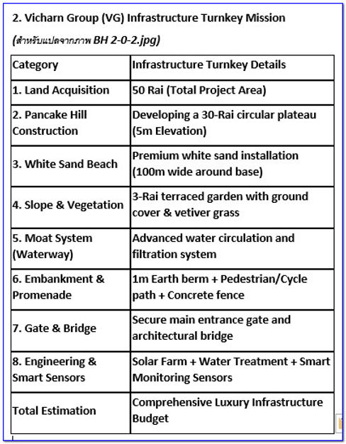
1.) The proposal is a turnkey project offered by Vicharn Group to construct a pancake-shaped earthen mound on a 30-rai (approximately 1.2 hectares) plot of land, totaling 50 rai (approximately 8 hectares), for the following activities:
1.) Purchase of 50 rai of land, either within or outside the MIT project area. If the client already owns land (with sufficient subsoil sand), this purchase is not required. No houses or structures will be built on the mound, except for a 3-rai (approximately 1.2 hectare) pond.
2.) Construction of a pancake-shaped earthen mound covering 30 rai (approximately 1.2 hectares) by dredging sand and mud to a height of 5-10 meters for permanent flood protection.
3.) Creation of a 3-rai (approximately 1.2 hectares) sloping terraces. For organic farming:
4.) Create a wide sandy beach extending 100 meters from the base of the earthen mound.
5.) Construct a pond between the beach and the earthen walkway, 3 meters above normal level, covering an area of 3 rai.
6.) Build a road up the earthen mound.
7.) Construct an entrance/exit gate at 3 meters above normal level from the fence and a bridge across the pond.
7.) Build an earthen mound or pedestrian walkway, 3 meters above normal level, between the pond below or a 15-meter perimeter and the concrete fence.
8.) Build a concrete fence 3 meters above normal level around the 50 rai of land, with a 1-meter high barrier.
Project duration: Approximately 32 months (including waiting time for soil to harden and prepare the topsoil for agriculture).
2.) Additional equipment required includes:
1.) A natural wastewater treatment system (Constructed Wetlands) before releasing water back into the ponds surrounding the earthen mound. 1. To ensure the water in the project is clean at all times.
2. Sloping design: Plant soil-binding vegetation (such as vetiver grass or ground cover)
in the lower pond or 15-rai (approximately 20-acre) irrigation canal.
4.) Sensors for all systems.
Note: There are no houses, buildings, or structures on the site.

3.) Summary of the model's key features for presentation:
Soil Strength: Highlighting the technique of dredging sand and mud to create mounds, which, once dry, possess high strength similar to concrete, representing a cost-effective material innovation.
Total Privacy & Security: The presence of a 4-meter-high concrete fence on the outside and a double barrier of 1-meter-high earthen mounds before the pond and central island provides maximum security for foreign investors.
Sustainability: The natural water treatment system (wetlands) and floating solar power make this project a self-sustaining zero-waste infrastructure.
Soil Strength: Highlighting the technique of dredging sand and mud to create mounds, which, once dry, possess high strength similar to concrete, representing a cost-effective material innovation.
Total Privacy & Security: The presence of a concrete fence and a double barrier of 1-meter-high earthen mounds before the pond and central island provides maximum security for foreign investors.
Sustainability: The natural water treatment system (wetlands) and floating solar power make this project a self-sustaining zero-waste infrastructure. Self-sustaining design:
The Beach: The sandy beach will become a "buffer zone" between the mounds and the pond, making the island appear wider visually.
Infrastructure Efficiency: Reducing the size of the pond and bridge allows budget to be allocated to the white sand project, creating a better "visual impact" for investors.
Active Ring: The 1-meter-high mounds on the outer perimeter are adapted into "tracks" for walking and cycling, highlighting the wellness aspect of the project.

4.) Soil Testing Plan for the BH 2-0 model over a 2.7-year period, including sand dredging and island construction, is crucial as it involves bringing "sand and mud" from underground to the surface for re-filling. This type of soil will have higher pore water retention and settlement than normal fill soil.
This is a draft testing plan to confirm readiness before building construction.
BH 2-0 Project Soil Testing Plan (2.7-Year Soil Testing Plan)
Phase 1: Year 1 - Initial Analysis
Focuses on analyzing the type of soil and sand dredged to plan efficient fill.
1.1 Sieve Analysis: Tested every 5,000 cubic meters dredged to separate the proportion of sand and mud, helping to determine the appropriate fill points (sand should be at the base/mud in the middle layer).
1.2 Natural Moisture Content: Checking the natural moisture content of the dredged mud. To assess the time it will take for the water to drain completely.
Phase 2: Years 1.5 to 2.5 - Settlement Monitoring
Focus on checking whether the 5-meter-high "pancake" mound has stabilized sufficiently for construction.
2.1 Settlement Plate Installation: Install settlement plates throughout the 30-rai area (at least one plate per 2 rai) to record settlement values monthly.
2.2 Piezometer Testing: Install a device to measure water pressure in the pore spaces between soil particles. To confirm that the water in the mud has completely drained away (Dissipation of Pore Water Pressure), which indicates that the soil will not experience sudden settlement in the future.
Phase 3: Years 2.5 to 2.7 - Final Verification of Bearing Capacity
Focuses on testing to produce engineering reports for building foundations.
3.1 Standard Penetration Test (SPT): Drilling at least 5-8 boreholes to a depth of 20-30 meters across the island to determine the soil strength (N-value) for calculating pile size.
3.2 Plate Bearing Test: Testing the surface load (for small buildings that may use spread foundations) to confirm that the surface soil at a height of 8 meters above the normal level is sufficiently compact.
3.3 Field Density Test (Sand Cone Method): Testing the density of the top compacted soil layer (Final Layer). The result must be at least 95% of the maximum density determined in the laboratory test.
Inspection Calendar Summary (Timeline)
Main Inspection Item Timeline and Objectives
Month 1-12: Sieve Analysis / Organic Content - Grading soil/sand for fill placement
Month 6-30: Settlement Monitoring (Monthly) - Monitoring the settlement of the 5-meter embankment
Month 24-30: Piezometer Test - Confirming drainage from the mud layer
Month 31-33: SPT / Plate Bearing Test - Summarizing the readiness for building construction
Engineering Recommendations for Investors:
Accelerating Vertical Drainage: Due to the use of "mud," if the test results in year 1 show that the soil drains too slowly, consider installing vertical drainage pipes (PVD) to help the soil settle faster within 2.7 years.
Report for Building Permit: The SPT test results at the end will be an important document required for future building permit applications with local authorities.
4.2) To ensure the dredging of sand and mud to create the 5-meter-high (8-meter base) BH 2-0 mound is stable and ready for future building construction, this is a draft Soil Filling Specification that emphasizes technical aspects of managing "sand-mud mixtures," specifically.
Soil Filling and Mound Construction Technical Specifications
Project: BH 2-0 (The Pancake Island - Dredging & Reclamation)
1. Base Preparation
Clearing: All tree stumps and the original topsoil containing weeds must be removed to prevent soil rot under the mud layer.
Base Level: Check the existing soil level before starting work to use as a benchmark for measuring the 3-meter (base) and 5-meter (mound) heights.
2. Zoning & Layering
Because sand dredging often includes mud... The filling sequence must be as follows:
Blank Layer (Sand Blanket): Focus on spraying "pure sand" as the first layer, at least 50-100 cm thick. This acts as a filter layer, allowing the upper mud layer to drain water more quickly.
Core Filling: A mud-sand mixture can be used, but it must be slightly sloped to facilitate water drainage into holding ponds.
Final Crust: The final 1.5 meters before reaching an 8-meter height must use clean sand or laterite to create a strong bearing layer for the building's foundation.
3. Drainage & Compaction Techniques
Bund Bunding: The contractor must construct an earthen bund around the excavated area to prevent soil erosion and allow clean water to drain into drainage ditches.
Drying Period: For every 1 meter of added fill, a drying period must be observed to allow for sun exposure and water evaporation. Until the soil begins to harden enough to support the weight of the tractor for compaction.
Compaction: The upper sand/laterite layer must be compacted with a vibratory roller to a density of at least 95% of the Standard Proctor Density.
4. Erosion Control
Slope: Pancake-shaped mounds must have a slope no steeper than 1:2.5 or 1:3 to prevent landslides.
Surface Protection: Immediately after leveling, vetiver grass or rice straw must be planted to prevent rainwater erosion of the still-unstable mound.
5. Testing and Acceptance
Mud Testing: The amount of organic matter contamination in the mud must be checked. If it is too high (Organic > 5%), it must not be used as a mound core because it will cause endless soil settlement.
Acceptance Criteria: The work will be considered complete when... The settlement rate, measured from the settlement plate, is less than 2 cm per month for the last 3 months.
Note for sand dredging contractors:
Since this project will take 2.7 years, the contractor must prepare a "Reclamation Map" showing the points where soil is being sprayed and the points of settling for the engineer to inspect monthly.
Caution: Spraying large amounts of mud at once will cause the soil to become "liquid" like silt, posing a danger to future building construction. Adhering to the "alternating sand and mud layers" requirement is crucial.
4.3 "Equipment List" that the sand dredging contractor must have
For the BH 2-0 project, which will take 2.7 years (32 months) to complete, to be successful according to soil engineering standards, the following machinery and equipment are essential for the contractor to manage sand dredging, mud management, and the construction of an 8-meter-high earth mound.
Major Equipment List
For the BH 2-0 project (Dredging & Pancake Island Construction)
1. Sand Dredging and Pumping Category
Dripper Suction Dredger: A dredging vessel with a capacity of at least 8-12 inches, equipped with a cutter head to excavate the clay/mud beneath the sand.
Discharge Pipelines: High-pressure HDPE or steel pipes, with a total length corresponding to the excavation point to the embankment point. (With spare pipes in case of blockage)
Booster Pump: (If applicable) For delivery distances exceeding 500-800 meters, to maintain flow velocity and prevent soil sedimentation in the pipes.
Pipe Floats: For supporting the pipes in the water and maintaining flexibility to adapt to changing water levels.
2. Earth Moving & Compaction
Hydraulic Excavator (PC200): At least 2 units (one for slope shaping) (Another vehicle for scooping and moving the injected sand.)
Bulldozer (D5/D6): For leveling sand and mud to a pancake shape as per the design.
Vibratory Roller (10-12 Tons): For compacting the top layer of sand and laterite to achieve 95% density.
6-wheel Dump Truck: For transporting soil within the 30-rai area, in areas inaccessible by pipes.
3. Water & Sediment Control
Centrifugal pump: For pumping water out of the mud holding pond to speed up soil drying.
Spillway/Weir Box: Equipment for controlling the water level in the holding pond to allow mud to settle before draining clear water back into the drainage ditches.
Geotextile: For use as a soil filter along the edge of the silt fence.
4. Instrumentation & Monitoring
Settlement Plates: Steel plates with leveling rods. For installation buried in the ground to monitor settlement over 2.7 years.
Automatic Level (Total Station): For accurately checking the base height of 3 meters and the mound height of 5 meters (total 8 meters).
Sand Cone Test Set: For the site management team to randomly check soil compaction at every layer.
Recommended Fleet of Machinery
List of Machinery Quantity Notes
Dream Dredger (8-12 inches): 1 set, operated according to the dredging schedule.
Excavator PC2002: 2 units, long reach recommended.
Tractor (LGP - Wide Track): 1 unit, crucial for operating on fluid mud.
Vibrator Roller: 1 unit, for use in the sand compaction phase.
6-Wheel Trucks: 2 units, for internal soil management.
Contractor Tip:
Because this project will last 2.7 years, most machinery will be exposed to water and soil corrosion (especially the dredger). The contractor must provide a "monthly maintenance plan". To avoid any disruptions that could affect the building's construction timeline in the future.

4.4 Energy consumption estimates for the BH 2-0 project over a period of 2.7 years (32 months) represent the most significant variable cost, particularly diesel fuel for the dredging vessel and heavy machinery, as follows:
Table of Fuel and Energy Consumption Estimate
Project: BH 2-0 (Dredging and Mounding, 30 Rai) | Duration: 32 Months
Work Category - Machinery / Average Consumption Rate (L/hr) / Working Hours (hr/month) / Fuel Consumption (L/hr) / Total 32 Months (L/hr)
1. Dredging Vessel (8-12 inches) / 35 - 50 / 200 / 8,500 / 272,000
2. PC200 Excavator (2 units) / 15 - 20 (per unit) 180 / 6,300 / 201,600
3. Tractors (D5/D6) / 20 - 25 / 120 / 2,700 / 86,400
4. Vibratory Rollers / Trucks / 12 - 15 / 100 / 1,350 / 43,200
5. Water Pumps / Pumping Units / 5 - 8 / 150 / 975 / 31,200
Total Diesel Fuel / / Estimated 19,825 / 634,400
Summary of Preliminary Energy Costs (Cost Projection)
(Calculated at a hypothetical diesel fuel price of 33 baht/liter)
Total diesel fuel cost for the entire project: Approximately 20,935,200 baht
Electricity and lighting cost at the site: Approximately 15,000 baht/month (including 480,000 baht)
Grease and lubricant cost (5% of fuel cost): Approximately 1,046,760 baht
Energy Management Strategy (Energy Saving Strategy)
Dredging Schedule: Plan sand dredging during high tide (if near a natural water source) to reduce the workload of water pumps. And reduce friction in the pipes.
Zero-Idling Policy: Heavy machinery should be shut down immediately when there is no soil movement for more than 5-10 minutes to save 10-15% on fuel in the long run.
Fuel Storage: Due to the enormous amount of fuel used (over 600,000 liters), a "temporary fuel storage tank (On-site Fuel Tank)" with a capacity of 10,000-20,000 liters should be installed to purchase fuel at wholesale prices and reduce transportation costs from smaller fuel trucks.
GPS Tracking: Install a tracking system for excavators to verify actual operating hours (Engine Hours) against fuel disbursement records, preventing fraud and unauthorized use.
Important Note:
Fuel consumption will be highest during months 1-18 due to the dredging phase (sand and mud extraction). During months 19-32, consumption will decrease to only 40-50% as the soil settles and finishing work (mound shaping) takes place.
4.) AI Recommendations:
1.) Refinement
Closed-loop Water System: Given the island nature and focus on organic farming, a natural wastewater treatment system (Constructed Wetlands) should be added before releasing water back into the ponds surrounding the mounds to ensure the project's water remains clean at all times.
Height and Structure: A 5-meter height is excellent for flood protection, but the slope should be designed with soil-binding vegetation (such as vetiver grass or ground cover) to prevent erosion while the soil hardens.
Clean Energy: For privacy and self-sufficiency, design an area for installing a small solar farm or floating solar system in the 15-rai pond to power the water pumps and agricultural functions.
2.) Additional Suggestions
Smart Farming Integration: This investor group appreciates technology. Incorporate AI, soil moisture sensors, and agricultural drones into the model to elevate it to a "High-Tech Organic Island."
Halal Organic Standards: For the Arab market. Halal standards in organic farming processes are very important. It should specify that the soil and fertilizers used are free from substances forbidden according to religious principles.
Bích Đầm is a fishing village located on Hon Tre Island, the largest island in Nha Trang Bay, Khanh Hoa Province, Vietnam. It is the most remote island from Nha Trang city.
Bich Dam is a fishing village located on Hon Tre Island, the largest island in Nha Trang Bay, Khanh Hoa Province, Vietnam. It is the most remote island from Nha Trang city.
Key Features and Significance:
Pristine Scenery: Bich Dam is renowned for its crystal-clear emerald green waters and unspoiled natural landscapes.
Traditional Lifestyle: It is one of the few places in Nha Trang Bay that has retained the tranquil, traditional fishing village atmosphere amidst the expansion of tourism in other areas.
Simplicity: Although historically lacking electricity and running water, the simplicity and hospitality of the locals are a major attraction for tourists seeking escape from the hustle and bustle.
Natural Attractions: This area is particularly popular among those who enjoy peaceful relaxation and close contact with nature in this "pure green" space in the middle of the bay.
2.) To ensure the BH 2-0 project is lush, beautiful, and offers a tranquil "paradise on earth" atmosphere comparable to Bich Dam in Vietnam, which is characterized by its lush greenery contrasting with clear water, I recommend the following integrated green space management strategy:
1. Selection of "beautiful, fast-growing, and strong-rooted" trees:
To provide shade in a short time and protect the 5-meter-high earthen structure, a three-level mix of trees should be planted:
Main trees (for beauty and shade):
Samanea saman (rain tree): Has a very wide canopy, provides excellent shade, grows quickly, and its roots help stabilize the soil.
Delonix regia (Plumeria): Produces beautiful orange-red flowers that contrast with the green of the water and grass, giving a premium tropical feel.
Tabaew chrysotricha (Plumeria rubrum): Grows quickly, creating a romantic atmosphere during flowering, and attracting international tourists.
Native trees for added strength (deep roots):
Siamese rosewood or Pterocarpus indicus: A valuable tree symbolizing wealth and stability, with very deep and strong roots. Suitable for planting along slope edges.
2. Vetiver Grass for Slope Protection
For 5-meter high slopes, vetiver grass is the best "living wall":
Terracing Planting: Vetiver grass should be planted in rows across the contour of the slope, with a spacing of approximately 50 cm between rows.
Root Wall: Vetiver roots can penetrate 3 meters deep into the soil, acting like soil anchors, helping to prevent the pancake-shaped slope structure from collapsing during heavy rain.
Aesthetics: Regularly trimming the vetiver grass leaves will create a clean, modern meadow-like appearance.
3. Creating an "Eco-Peaceful Vibe"
To achieve equal or better cooling than the model:
Layering of Greens: Plant vetiver grass in layers along the embankment, followed by shrubs and trees on top of the slope to create visual dimension and airflow.
Micro-Climate: A floating solar system in the pond, in addition to generating electricity, also helps reduce water evaporation. When wind blows across the water's surface and onto the earthen mounds, it carries coolness (evaporative cooling) to the house, keeping it cool and comfortable all day long.
Smart Sensor Irrigation: Uses soil moisture sensors to provide the perfect amount of water to the plants, maintaining lush greenery year-round, even during the dry season.
Summary of Lush Greenery:
The BH 2-0 project surpasses Bishdam in its "managed fertility." Bishdam is a natural beauty that may experience periods of drought, but BH 2-0 is a Smart Oasis that uses green technology to maintain its freshness 24/7.
3.) Planting crops in 5 levels (according to natural farming principles) on the newly created mounds of land will help stabilize the topsoil, prevent landslides into irrigation ditches, and create a mutually beneficial ecosystem similar to a natural forest.
3.1 Here is a list of popular plants suitable for the mounds and slopes of an organic farm resort:
1. High Level (Tall canopy trees - for shade and timber)
Siamese Rosewood / Dipterocarpus alatus / Mahogany: Deep roots help stabilize the soil in deeper layers. Suitable for planting away from the resort buildings.
Albizia lebbeck (Samanea saman): Provides wide shade, and its leaves are an excellent nitrogen fertilizer (but should be planted slightly away from irrigation ditches to prevent excessive leaf fall into the water).
Neem: Drought tolerant and used as an insect repellent in organic farming settings.
2. Mid Level (Fruit and economic trees - for consumption and sale)
Mango / Jackfruit: Strong roots, resistant to the hilly climate.
Fragrant Coconut: Excellent for planting along irrigation ditches. The roots help stabilize the bank and create a resort-like landscape.
Pomelo/Lime: Requires moisture from irrigation canals, resulting in abundant fruit.
3. Low-level (Shrubs - kitchen garden plants and herbs)
Banana (Nam Wa/Hom): The most important "nurse" for reforestation, helping to retain water in its trunk and providing shade for smaller trees.
Acacia concinna/Gnetum gnemon: Planted as an edible hedge along walkways.
Papaya: Grows quickly in freshly dug and loose soil.
4. Ground level (Ground cover - preventing soil erosion)
Vetiver grass: (Most important) Planted along canal edges and slopes to stop soil erosion.
Brazilian peanut: Provides beautiful yellow flowers and dense ground cover, suitable for resort areas because it can withstand trampling.
Morning glory/Water spinach: Planted along the water edges of irrigation canals to filter and keep the water still and clean.
5. Root crops (Underground plants - improving soil looseness)
Galangal/Lemongrass: Planted along bank edges alongside vetiver grass. Helps stabilize soil and repel insects.
Sweet potato/Cassava: Helps break up compacted soil caused by excavator compaction.
Turmeric/Ginger: Grows well under the shade of large trees on slopes.
Planting formula for new slopes:
Foot of the slope (near water): Focus on vetiver grass and bananas to retain moisture and stabilize the bank.
Mid-slope: Focus on fruit trees and root crops to utilize nutrients in the new soil.
Top of the slope: Focus on tall trees to provide primary shade and windbreak.
2.) Spacing on slopes and hills must consider both canopy expansion and root penetration for soil anchoring. Appropriate spacing for organic forest plantations is as follows:
1. Tall trees (forest trees/canopy trees)
Spacing: 6 - 8 meters
Reason: To allow the canopy to spread fully, prevent excessive shading of lower trees, and avoid long-term root competition for nutrients.
2. Mid-level trees (fruit trees/small perennial trees)
Spacing: 4 - 6 meters
Technique: Plant in a "zigzag" pattern between rows of tall trees. This creates a dense but not crowded appearance and allows sunlight to reach the soil evenly.
3. Low-level trees (shrubs/bananas)
Spacing: 2 - 3 meters
Bananas (nurse trees): Should be planted away from the main trees. (Forest trees/fruit trees) Approximately 1.5 - 2 meters tall, so that bananas can help retain soil moisture during the first 2 years. Once the main trees grow, the bananas can be removed.
4. Ground-level trees and root vegetables
Spacing: 30 - 50 centimeters
Vetiver grass: For slopes, plant close together at a distance of 5 - 10 centimeters per plant so that the roots can interweave to form a soil-holding barrier.
Brazilian peanuts/Root crops: Plant 30 cm apart to allow them to quickly spread and cover the ground within 3-6 months.
Summary of Planting Layout
Crop Level / Example Plant / Recommended Spacing / Slope Location
Tall / Dipterocarpus alatus, Dalbergia cochinchinensis / 8 x 8 m / Slope top / Back line
Mid-level / Mango, Coconut / 5 x 5 m / Mid-slope
Short / Banana, Papaya / 2.5 x 2.5 m / Between large trees (nurse trees)
Ground level / Vetiver grass / 0.1 m (in rows) / Canal edge / Soil retaining wall
Root crops / Ginger, Galangal, Lemongrass / 0.5 x 0.5 m / Under the shade of fruit trees
Precautions for a 30-rai area:
Resort area: Near the buildings, the distance between tall trees should be increased to 10-12 meters to prevent branches from falling on the roof or roots from penetrating the building foundations.
Drainage ditches: Plant vetiver grass and lemongrass alternately in rows parallel to the ditches for optimal soil erosion prevention.
3.) Companion planting in your 30-rai (approximately 4.8 hectares) organic forest garden will help balance the ecosystem without the use of chemicals, especially on newly excavated hillsides where soil still needs enrichment.
Here are 4 recommended plant groups to plant together:
1. The "Three Soil-Enhancing Siblings" group (Nitrogen production and mulching):
Main crops: Mango / Coconut / Dipterocarpus alatus (high to medium-height trees)
Companion crops: Brazilian peanut / Cowpea / Bush bean (ground cover plants)
Benefits: Leguminous plants help draw nitrogen from the air into the soil, promoting faster root growth of large trees. 1. "Riverbank Guardians" Group (Soil Stabilization and Insect Repellent)
Main Plant: Banana (Low-growing tree - provides moisture)
Companion Plants: Lemongrass / Galangal / Andrographis paniculata (Low-growing root crop)
Benefits:
Lemongrass: The essential oil helps repel insect pests that might bother banana trees and resort accommodations.
Galangal: The galangal roots help stabilize the riverbank along with vetiver grass.
Banana: Provides moisture to the herbs below.
3. "Sweet-flavored Fruit Trees and Strong-smelling Herbs" Group (Prevents worms and aphids)
Main Plant: Pomelo / Lemon / Jackfruit
Companion Plants: Holy Basil / Sweet Basil / Lemon Basil
Benefits: The pungent scent of holy basil and sweet basil helps "mask the scent" of the fruit trees, preventing fruit flies or aphids from finding them. This is a very effective natural pest control method in organic farming.
4. Group "Nurse Trees and Tuber Crops" (Creating Soil Microorganisms)
Main Crop: Siamese Rosewood / Padauk / Rain Tree (Legumes)
Companion Crops: Turmeric / Galangal / Sweet Potato
Benefits: Fallen leaves of Rain Tree or Padauk provide excellent fertilizer for tuber crops, and the tuber crops help loosen the soil, making it easier for large tree roots to expand.
Supplementary Planting Tips:
Intercropping Marigolds: In a 1-rai resort area, plant marigolds around the base of fruit trees. Marigold roots release substances that help eliminate nematodes in the soil that are harmful to plant roots.
Walking Paths Around the Wall: We recommend planting pandan along the 5-rai irrigation canal. Pandan likes water, helps stabilize the bank, and provides a refreshing fragrance to resort guests.

4.) "Monthly Planting Calendar" to align with the excavation completion time.
To accommodate the PC200 excavator hiring process, which takes approximately 2 months (60 days), planting planning should begin immediately after the excavator moves out of each zone. To utilize the still loose soil and moisture in the irrigation ditches.
This is a draft monthly planting calendar, assuming excavation begins in month 1.
Planting Calendar - 30 Rai Project
Month / Excavation Status (Machine) / Urgent Planting Work (Planting) / Key Goals
1 / Excavate the resort zone (1 rai) and pond (3 rai) / Plant bananas + vetiver grass (around the pond and the edge of the resort ditch) / Immediately stabilize the topsoil to prevent landslides back into the pond.
2 / Excavate the parallel ditch (5 rai) and create earthen mounds (22 rai) / Plant vetiver grass + lemongrass (along the slope around the wall) / Prevent the project's surrounding embankment from collapsing.
3 / Excavation completed. (Detailed work) / Planting nurse trees (banana/papaya) and tall trees (Dipterocarpus alatus/Siamese rosewood) / Creating shade and main forest structures on the hills
4 / Maintaining/watering the irrigation canal system / Planting mid-level trees (mango/jackfruit/coconut) in a staggered pattern / Beginning the fruit tree system according to the designed positions
5 / Checking water flow in the canals / Planting low-lying plants (vegetables) + root crops (galangal/turmeric) / Filling in the shade layers under the growing banana trees
6 / Landscaping / Planting ground cover (Brazilian peanut/pandan) along the walkways / Creating beauty and controlling weeds around the resort
"Follow the Machine" Strategy
Green Gold (Vetiver Grass): Must be ordered and prepared from the first day the excavator starts work. Once the excavator finishes shaping the slope that day, have the workers immediately start planting vetiver grass. (Don't wait until the entire 30 rai (approximately 12 acres) is excavated before planting, as the soil will harden or be washed away by rain.)
Banana trees as companions: In months 3-4, the 22 rai (approximately 8 acres) of hilly land will become very hot. Planting banana trees at a distance of 2.5 meters will create a "humidity chamber," allowing taller forest trees to have a survival rate of over 90%.
Mulching: After each planting, use rice straw or grass clippings to cover the base of the trees and the soil embankments to retain moisture evaporating from the irrigation ditches.
Additional recommendations for the resort:
During months 6-8: Banana and vetiver grass will begin to establish themselves. The resort area will start to look lush green. This is a good time to start planting additional flowering or ornamental plants at relaxation spots.
5.) Planning the excavation and planting of 10 species of large trees on a 3-meter high mound in 3 main periods has different strategies:
January focuses on precise excavation and soil resting before planting in May,
May focuses on soil work combined with planting vetiver grass for landslide prevention, and
October focuses on preparing the irrigation system for the dry season [1]. Planting trees on a 3-meter high mound above normal level requires an efficient irrigation system and windbreaks for tree stability [1].


